")
Using Physics to Find Archaeological Remains
- Last Updated: Tuesday, 28 June 2022 09:20
- Published: Monday, 18 April 2022 10:29
- Written by Jean-Olivier Gransard-Desmond translated by Leah Gallet and Maura Schmitt
- Hits: 1404

Join Augustin, Alex, Lisa and the whole ArkeoTopia team to discover additional resources for step 2.5 in My Archaeology Book about locating the former presence of human beings using geophysical survey.
Step 2.5 - Finding Archaeological Remains
Geophysical Survey
Corresponding pages in MAB1 and MAB2
MAB 1, p. 10 (step 4.4, p. 13 in the 1st edition) and MAB 2, p. 12
More about this step’s reference artifact
 The drawing to illustrate step 2.5 in My Archaeology Book, titled Geophysical Survey, shows an archaeologist on the verge of uncovering two ancient Gallo-Roman walls hidden just beneath her feet. She is using geophysical prospecting, a method that applies our understanding of materials physics in order to allow archaeologists to “see” underground and thus locate previous human activities.
The two walls that Lisa, the archaeologist, has identified with her magnetometer could be part of a great number of different buildings that have been attributed to Gallo-Roman culture, which, according to historians, began at the end of Caesar’s Gallic Wars around 50 BCE. The structures that are most frequently unearthed are Roman villas. The villas’ complex design easily explains why Lisa discovered two walls right next to each other.
In contrast with accidental discoveries made by explorers, or discoveries made by chance, archaeologists in the mid-twentieth century developed a rigorous method for exploring an area in a methodical and systematic way in order to reveal clues about previous human activities –- the survey method. There are several types of survey methods that have been developed over time, including fieldwalking, aerial survey, and satellite archaeology. The most recent and also the most expensive method is geophysical survey.
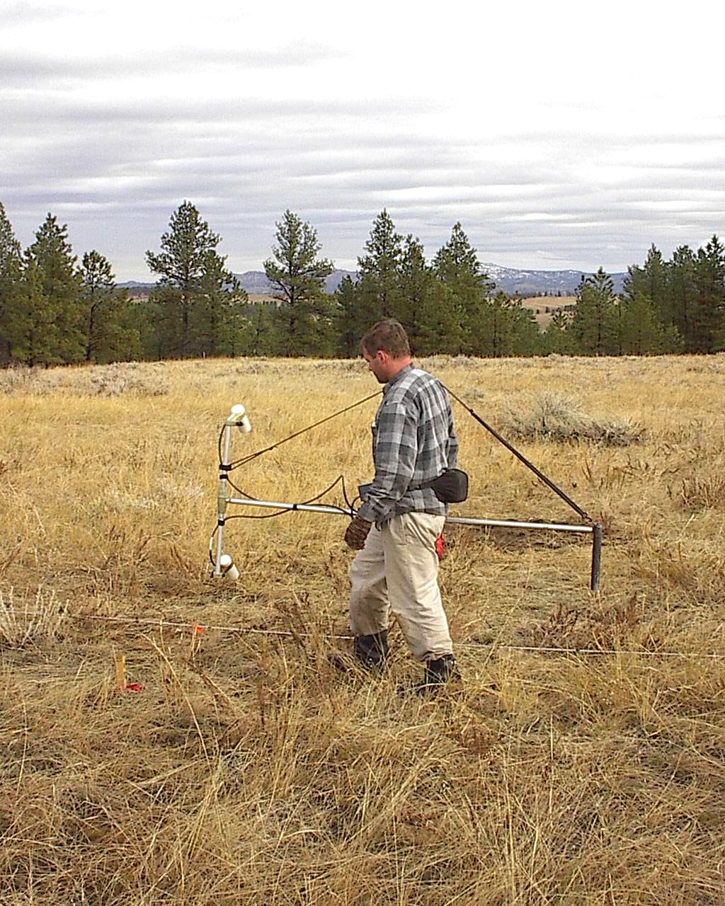
 Geophysical surveys use non-destructive methods, meaning that they do not disturb the soil. This is because this kind of survey does not involve immediate excavation, as the data from the sensors must first be analyzed in order to act accordingly. Moreover, archaeologists are not necessarily involved in the survey process, although they can contribute to data collection, as Lisa is seen doing here. Trained physicists are needed in order to set up the sensing instruments as well as read the data collected by them. Understanding the data requires knowledge in materials physics that is not typically part of an archaeologist’s training.
In the drawing, the sonar technology being used by the magnetometer is represented by Radar, the bat, seen emitting ultrasound waves to reveal obstacles in his path. The device Lisa is holding uses the same technology to determine whether or not there are artifacts or other archaeological remains under her feet. Collaboration with physicists and engineers allows archaeologists to locate “hot spots,” where underground anomalies (irregularities regarding the expected pattern which means potential archaeological remains are here) reveal traces of past human activities, including walls, ditches, piles of rubble, etc. In this way, archaeologists are able to locate evidence of human activity that are otherwise invisible to the naked eye.
Recent developments in soil physics in combination with the latest technological advancements have enabled these geophysical devices to locate not only stone walls underground, but walls made from clay or brick as well. Another recent technology called lidar has gone one step further, enabling the detection of anomalies underground despite aboveground vegetation. This technology is often referred to as 3D laser scanning. Using this technology, archaeologists could glean topographical data about a forest, for example, even from above its canopy of vegetation.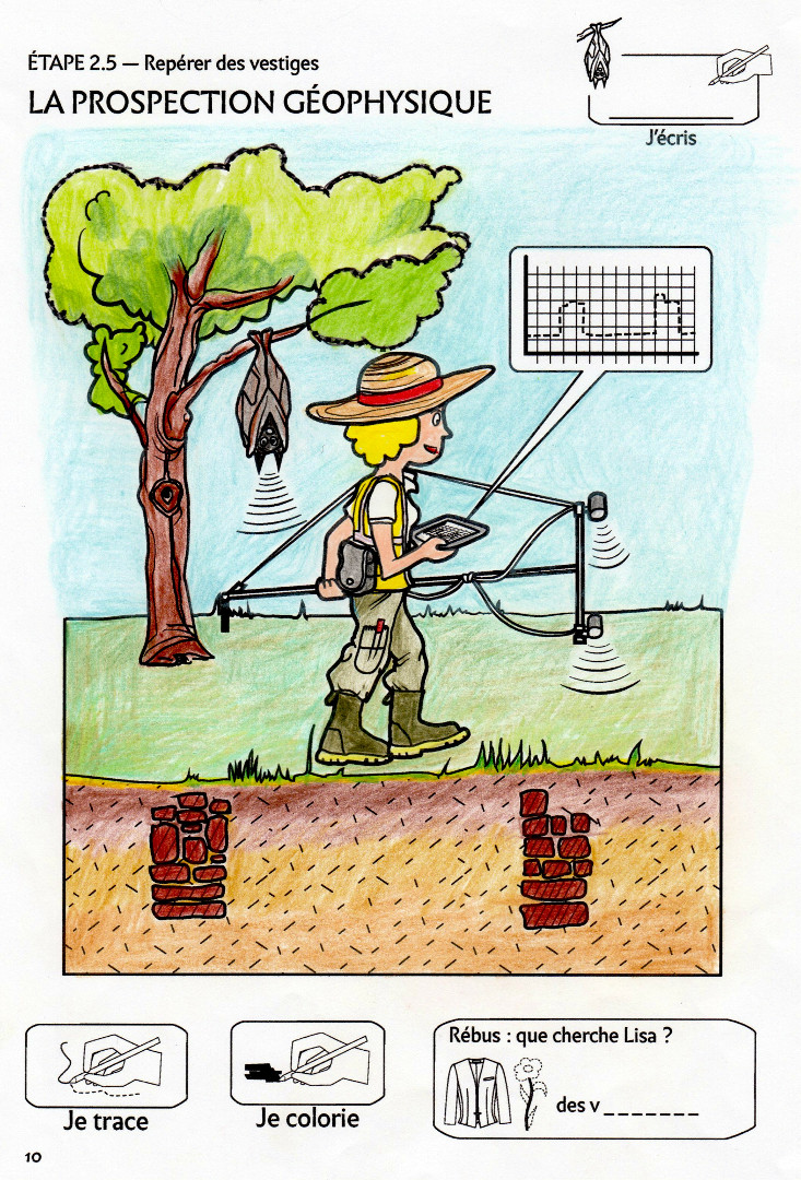 In the drawing, Lisa is using a caesium vapor magnetometer with two sensors that measure the intensity or the direction of a magnetic field. This device displays two peaks on her tablet screen that appear to indicate the presence of two stone walls underneath her. At the same time, Radar, the bat, is hanging lazily from the tree as his echolocation abilities mimic those of the magnetometer signals, representing the similarity of how these two mechanisms work.
Vocabulary
A clue is a noticeable sign pointing to a fact or phenomenon.
In archaeology, for example, anomalies detected using geophysical survey techniques are considered clues of a potential former presence of human beings and thus a possible archaeological dig site.
An anomaly (irregularity) is something that deviates from the expected pattern, or from what is typical, which means potential archaeological remains are here. For example, the two peaks seen on Lisa’s screen deviate from the rest of the graph.
Clues
The 6 clues include:.
- Lisa, the archaeologist, in full survey gear with her hat, boots, reflective jacket, and notebook
- The survey device carried by Lisa, in this case a magnetometer
- The tablet and the enlarged screen which shows what the magnetometer detects under the ground
- The magnetometer transmissions
- Radar, the bat, who exemplifies the way the magnetometer functions
- The underground relics, remnants of Gallo-Roman walls
Using Aerial SurveyMy Archaeology Book
Resources HomepageStep 2.6 - Location
Finding by Inventorying
 |
 |
|
My Archaeology Book 1 |
My Archaeology Book 2 |

 My Archaeology Book, or MAB, is an activity workbook that combines creativity, fun and learning. Alongside young Augustin, a curious and courageous boy, children meet Alex and Lisa, two friendly archaeologists who will lead them to discover archaeology and French heritage. Each drawing illustrates a situation that Alex and Lisa might encounter at work. Depending on the age of the child and the workbook, children follow easy-to-understand symbols in order to experiment with activities such as coloring, drawing, observation games, riddles and reading in order to see the world through an archaeologist’s eyes. Alone, with family, at school or just for fun, children expand their knowledge and gain skills, all while having fun.
On this section, you will find additional resources: color photos of archaeological documents that inspired My Archaeology Book, additional teaching documents (flip-book, websites, suggestions for classroom use, edutainement, etc.) and information on upcoming publications. Each page will be updated over time.