")
Finding Archaeological Remains by Plane
- Last Updated: Tuesday, 28 June 2022 09:45
- Published: Saturday, 19 February 2022 15:52
- Written by Jean-Olivier Gransard-Desmond translated by M. Schmitt and F. Guichon
- Hits: 1550

Join Augustin, Alex, Lisa and the whole ArkeoTopia team to discover additional resources for step 2.4 in My Archaeology Book about locating ancient human occupations through aerial surveys.
Step 2.4 - Locating Archaeological Remains
Aerial Survey
Corresponding pages in MAB1 and MAB2
MAB 1, p. 9 (step 4.3, p. 12 in the 1st edition) and MAB 2, p. 11
More about the step’s reference artifact

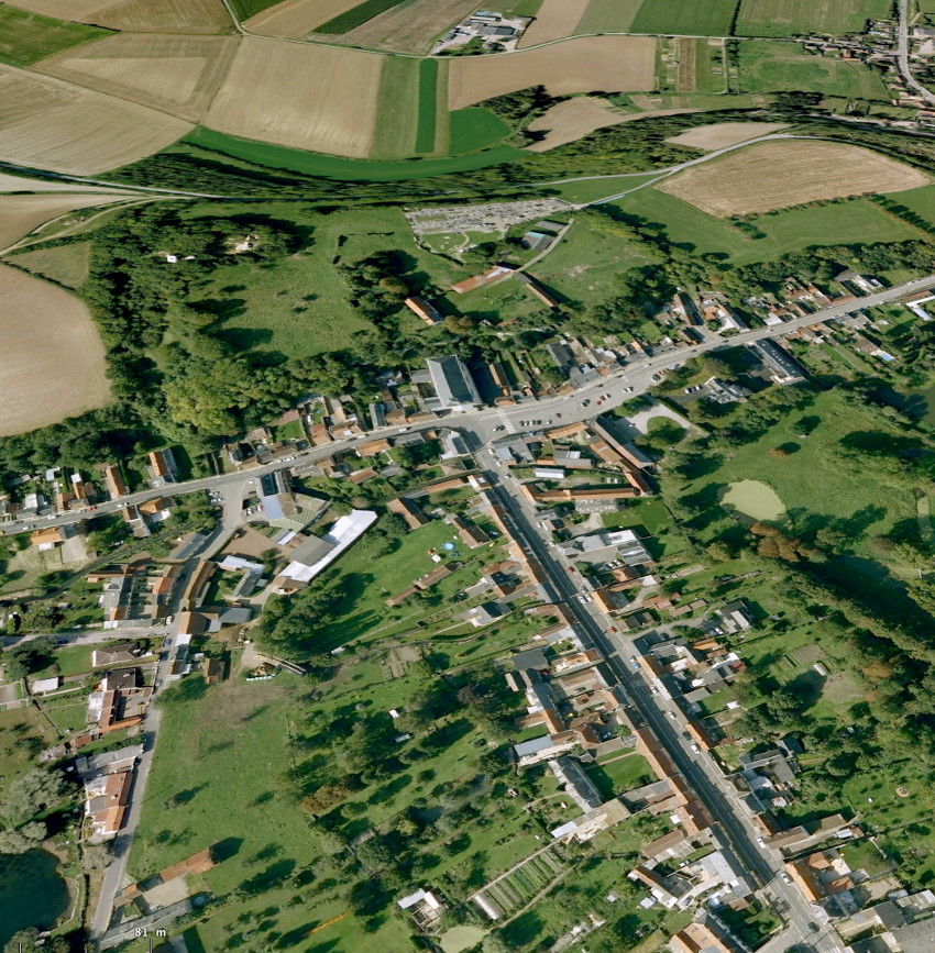 The motte-and-bailey castle of Boves served as the inspiration for pages 9 and 11 of My Archaeology Book, titled Aerial Survey, one method archaeologists use to locate human presence like settlements, buildings, trenches and so on.
This medieval defense site was added to the register of Historic Monuments (Monuments Historiques) on March 4, 1926. Located near the town of Boves, about 5 miles southeast of Amiens, in the Somme, the site features two primary points of interest for French medieval archaeology: a long history of occupation, from the 10th to the 16th century; and remains in remarkable condition, with dry-stone and dimension stone constructions and a significant U-shaped ditch extending about 150 feet and almost 70 feet deep. The site was surely chosen by the seigneurs of Boves due to the presence of two confluent rivers, the Noye and the Avre.
This motte-and-bailey castle was constructed in the early 10th century by the occupants and included two baileys, or courtyards. The motte, or earthen mound, was built up and reformed several times to accommodate timber then stone structures. This fortified aristocratic residence belonged to different powerful families including a branch of the Coucy family from the 11th to the 12th century and the dukes of Lorraine from the 14th to the 16th century. After its last period of construction, the château was dismantled in 1595. It then served as a rock quarry, as abandoned buildings often did at the time. In the 19th century, only the ruins of the last tower remained on the motte, as evidenced by drawings and paintings and as mentioned very briefly by the presumably disappointed Victor Hugo, during his visit in August 1835: “I saw the ruins […] of Boves, a great fractured keep...” If he was around today, Victor Hugo could admire the importance of the site, which we now see, thanks to the archaeological research led by Professor Philippe Racinet, is much more than a great fractured keep.
We now know that the site comprises three distinct areas:
- the motte to the southeast
- a first bailey, including the seigneurial residence and the outbuildings, and an intermediate space occupied by Notre-Dame church and the Cluniac priory of Saint-Aubert
- a second bailey further north
Clues
The goal here is to show how archaeologists are able to locate human presence which are not clearly distinguishable during a field survey (fieldwalking).
The 4 clues include:
- Piercy the eagle
- The plane
- The camera held by Alex, the archaeologist
- The circle of trees which represent the landscape anomaly
Like Alex, young archaeologists have to:
- have sharp eyes, like an eagle, to detect anomalies in the landscape
- quickly analyze the big picture to choose which photographs to take
- snap a few shots at the right moment, taking into account the position of the plane in relation to what they saw on the ground, the plane’s altitude and the sunlight in order to achieve the best pictures they can possibly manage
Analyzing the images after the flight is the best way to detect the anomalies that were visible from the sky. Here, for example, the circle of trees indicates a potential human settlement.
Go to Wikimedia Commons to discover photos from aerial surveys shot by Jacques Dassié, one of the first aerial archeologists.
Via Satellite ImageryMy Archaeology Book
Resources HomepageStep 2.5 - Location
Geophysical Surveys
 |
 |
|
My Archaeology Book 1 |
My Archaeology Book 2 |

 My Archaeology Book, or MAB, is an activity workbook that combines creativity, fun and learning. Alongside young Augustin, a curious and courageous boy, children meet Alex and Lisa, two friendly archaeologists who will lead them to discover archaeology and French heritage. Each drawing illustrates a situation that Alex and Lisa might encounter at work. Depending on the age of the child and the workbook, children follow easy-to-understand symbols in order to experiment with activities such as coloring, drawing, observation games, riddles and reading in order to see the world through an archaeologist’s eyes. Alone, with family, at school or just for fun, children expand their knowledge and gain skills, all while having fun.
On this section, you will find additional resources: color photos of archaeological documents that inspired My Archaeology Book, additional teaching documents (flip-book, websites, suggestions for classroom use, edutainement, etc.) and information on upcoming publications. Each page will be updated over time.